Order on the formation of the layout of the land plot. Where can I get and approve the layout of the land plot on the cadastral plan of the territory? purchase a plot through approval of a land plot scheme
Each piece of land must be defined by boundaries. The formation of the allotment should be carried out on the basis of the layout land plot on the cadastral plan territory (hereinafter SRZU), approved by the authority local government. This data is stored in the state register and is open to every citizen who has applied to the official website of Rosreestr.
What is the layout of the land plot on the cadastral plan of the territory?
SRZU is an image with plotted boundaries of the formed plot or plots on the cadastral plan of the territory. Such a scheme is formed by cadastral engineers based on the results.
The scheme should contain the area of each of the formed sections. If two or more allotments are involved in the formation process, then their conditional numbers are present in the document. The scheme should complement the boundary case.
The preparation of the document is regulated by Article 11.10 Land Code. The requirements for its formation and form were approved by the order of the Ministry of Economic Development of November 27, 2014 No. 762.
Why do we need a layout plan for a land plot at a KPT?
The scheme itself is not a title document. It is technical in nature and requires:
- in order to form a memory from lands or other plots located in the state or municipal property, i.e. not owned by private individuals;
- in case of redistribution of the memory located in private property with lands of state or municipal property, the so-called undercut.
The most common cases where preparation of a storage layout is required:
- a cadastral engineer is required to prepare a land survey plan in order to put it on the cadastral register and obtain a cadastral number of the plot;
- own on leasehold land located in state property and want to share it. In this case, approval of the scheme for the division of such a section is required;
- want to formalize an empty piece of land that belongs to no one, get it on lease or property (purchase) in accordance with the land code.
- may be required in case of obtaining a building permit.
In other cases, land is allocated by local governments in accordance with the land surveying and planning project.
The scheme is approved for a certain period of time, according to the law, the period is - 2 years.
The structure of the document must contain all necessary information on allotment in accordance with Art. 11.10 RF LC. The layout of the site reflects the following information about the formed allotment:
- conditional number;
- square;
- location;
- coordinates of boundary turning points;
- red lines;
- boundaries of territorial zones with established special conditions use;
- the position of capital buildings;
- planning projects;
- borders of adjacent sites;
- drawing of the issued allotment;
- number of the cadastral quarter;
- description of the coordinate system;
- symbols;
- land category.
It is preferable to conduct a topographic survey of the site and its environs. It entails additional expenses, but will have a positive effect on the accurate reflection of the actual characteristics of the site. For example, it will show what communications pass under the land, which will avoid problems with its subsequent development.
Stages of preparing the layout of the memory
The initiator of the formation of a land plot in order to obtain a scheme for its location must act in the following order:
1. An interested person prepares a statement on the need to prepare a layout plan for a plot of land. The basis for this is a document confirming the authority of the applicant regarding this allotment.
2. A package of documents is being prepared that must be attached to the application. It includes:
- applicant's passport;
- a document of title to a plot of land (certificate of ownership, act of allotment of a plot, etc.);
- cadastral passport for land (if available) or an extract from the USRN;
- a certificate from the BTI, if there are buildings on the site, or a cadastral extract, if there are none.
3. An application with documents is sent to the cadastral engineer. Before starting work, a contract is drawn up for the provision of services for the manufacture of the scheme.
4. The received documents are analyzed by a specialist for the presence or absence of grounds for refusing to approve the layout of the storage facility. To do this, he requests the registration data of the site in the form of a cadastral extract.
The schema can be prepared in one of the following ways:
- Analytical.
- With the departure of a specialist to the place.
In the first case, the preparation is done in camera. The boundaries of the memory are approximately projected and the layout is being prepared. In this case, there is a risk, after approval and registration of the right to a plot, to receive an allotment not within the boundaries that you want. This is especially dangerous if there are some other real estate objects (foreign plots, buildings, etc.) around the site you have chosen. If there are risks of crossing the boundaries of someone else's property, it makes sense to prepare a scheme with the departure of a surveyor. It is a little more expensive, but justifies the money spent in case of crossing plots of land with neighbors.
Upon departure, the geodesist will determine the exact coordinates of the boundaries of this site and a scheme will already be prepared according to them.
5. Obtaining an official document. The term of its preparation usually takes from two to four weeks.
After approval, the cadastral engineer can prepare a boundary plan, conduct a cadastral registration of this formed allotment. At the exit, you will receive a registered plot with a cadastral number, and an extract from the USRN has been issued.
After this procedure, you can begin the process of registering the right to a piece of land and you will have a property. Before cadastral registration, there can be no talk of a real estate object, since, in accordance with Russian legislation a real estate object arises after its cadastral registration and the appearance of a cadastral number.
A citizen can independently, using the Rosreestr portal, prepare this scheme. But not everyone has all the necessary information to verify compliance with all regulations. This is a fairly large amount of information that a cadastral engineer usually owns. Therefore, it is recommended not to waste time and contact qualified specialists.
Sample SRZU for KPT 2019:

Registration of SRZU by the administration
In most cases, the initiator of the preparation of the scheme is an interested person: an organization or a citizen. The obligation to issue it by the territorial administration is only the case of the sale of the site by auction. The applicant bears all costs associated with the production and receipt of the SRZU.
The body that allocates land sends an electronic scheme to the Rosreestr. This is necessary so that another site does not form at this place until the moment of registration of the right to it or in the next two years (the period of the scheme).
It is a violation on the part of the administration to require the applicant to submit the scheme in in electronic format. This claim is illegal!
Reasons for refusal
In order for the scheme to be approved, it must comply with the requirements of the land code and, accordingly, must not fall under the clauses that are the basis for refusal of approval. If the document meets all the requirements of urban planning regulations and legislation, then local governments are required to approve it.
According to paragraph 16. Art. 11.10 LC, reasons for refusal may be if the scheme:
- does not comply with the format or requirements for its preparation;
- has violations of the requirements land legislation to the formed allotments;
- does not comply with the approved project for planning the territory, as well as the regulation on specially protected natural zones, urban planning standards;
- has other violations of land legislation.
They will also refuse if the boundaries of the area being created:
- cross another section already registered in the cadastral register;
- cross the boundaries of the land plot for which the scheme with the current term is approved;
- do not comply with the territory planning project or land management standards;
- within the approved survey project. In this case, it will become a problem to obtain the desired piece of land for rent or ownership. The way out here is to include it in the project.
What to do if you get rejected?
Further actions of the person interested in obtaining the scheme depend on the basis on which the refusal was received.
In case of refusal due to data mismatch with the Rosreestr databases (cadastral error), it is necessary to submit a request for their correction. A variant of events may be making changes and receiving an extract or refusal. The refusal must be submitted in writing, indicating the reason. Then with this document you can apply to the court, which, by its decision, will oblige the Rosreestr body to make changes.
If the administration refused to approve the layout of the land plot due to non-compliance with the legal format or violation of the preparation rules, then the applicant has the right to start the procedure again. You can do it again with the same cadastral engineer or contact someone else.
"On approval of requirements for the preparation of a land plot layout plan or land plots on the cadastral plan of the territory and the format of the layout of the land plot or land plots on the cadastral plan of the territory when preparing the layout of the land plot or land plots on the cadastral plan of the territory in the form electronic document, forms of the layout of the land plot or land plots on the cadastral plan of the territory, the preparation of which is carried out in the form of a document on paper"
Edition of 10/13/2016 - Valid from 11/14/2016
Show changes
MINISTRY OF ECONOMIC DEVELOPMENT OF THE RUSSIAN FEDERATION
ORDER
dated November 27, 2014 N 762
On the approval of the requirements for the preparation of the location of the land or land on the cadastral plan of the territory and the format of the location of the land plot or land on the cadastral plan of the territory in the preparation of the location of the land or land on the cadastral plan of the territory in the form of an electronic document, the form of the location scheme LAND PLOTS OR LAND PLOTS ON THE CADASTRAL PLAN OF THE TERRITORY, THE PREPARATION OF WHICH IS CARRIED OUT IN THE FORM OF A DOCUMENT ON PAPER
dated 13.10.2016 N 658)
1. Approve:
requirements for the preparation of the layout of a land plot or land plots on the cadastral plan of the territory and the format of the layout of the land plot or land plots on the cadastral plan of the territory when preparing the layout of the land plot or land plots on the cadastral plan of the territory in the form of an electronic document (Appendix No. 1);
the form of the layout of the land plot or land plots on the cadastral plan of the territory, the preparation of which is carried out in the form of a document on paper (Appendix No. 2).
Minister
A.V. ULYUKAEV
I. General provisions
1. Requirements for the preparation of the layout of a land plot or land plots on the cadastral plan of the territory and the format of the layout of the land plot or land plots on the cadastral plan of the territory when preparing the layout of the land plot or land plots on the cadastral plan of the territory in the form of an electronic document (hereinafter referred to as the Requirements ) establish the rules for drawing up the layout of the land plot or land plots on the cadastral plan of the territory (hereinafter referred to as the layout of the land plot).
2. The layout of the land plot is prepared in relation to the land plot or land plots formed in accordance with the requirements of the Land Code Russian Federation <*>(hereinafter referred to as the Land Code).
<*>Collection of Legislation of the Russian Federation, 2001, N 44, Art. 4147; 2003, N 27, Art. 2700; 2004, N 27, Art. 2711; No. 41, art. 3993; No. 52, Art. 5276; 2005, N 1, art. 15, 17; No. 10, art. 763; No. 30, Art. 3122, 3128; 2006, N 1, art. 17; No. 17, Art. 1782; No. 23, Art. 2380; No. 27, Art. 2880, 2881; N 31, art. 3453; No. 43, art. 4412; No. 50, art. 5279, 5282; No. 52, Art. 5498; 2007, N 1, art. 23, 24; No. 10, art. 1148; No. 21, art. 2455; No. 26, Art. 3075; N 31, art. 4009; No. 45, Art. 5417; No. 46, Art. 5553; 2008, No. 20, art. 2251, 2253; No. 29, art. 3418; No. 30, Art. 3597, 3616; No. 52, Art. 6236; 2009, N 1, art. 19; No. 11, Art. 1261; N29, Art. 3582, 3601; No. 30, Art. 3735; No. 52, Art. 6416, 6419, 6441; 2010, N 30, Art. 3998; 2011, N 1, art. 47, 54; No. 13, Art. 1688; No. 15, art. 2029; No. 25, art. 3531; No. 27, Art. 3880; No. 29, art. 4284; No. 30, Art. 4562, 4563, 4567, 4590, 4594, 4605; No. 48, Art. 6732; No. 49, Art. 7027, 7043; No. 50, art. 7343, 7359, 7365, 7366; N51, art. 7446, 7448; 2012, N 26, art. 3446; N 31, art. 4322; No. 53, art. 7643; 2013, N 9, art. 873; No. 14, Art. 1663; No. 23, Art. 2881; No. 27, Art. 3440, 3447; No. 30, Art. 4080; No. 52, Art. 6961, 6971, 6976, 7011; 2014, N 26, art. 3377; No. 30, Art. 4218. 4225. 4235: No. 43. art. 5799.
3. The layout of the land plot determines the projected location of the boundaries and the area of the land plot or land plots that are supposed to be formed and (or) changed.
4. The layout of the land plot is prepared on the basis of information from the state real estate cadastre on a certain territory (the cadastral plan of the territory). When preparing the layout of the land plot, materials and information are taken into account:
approved territorial planning documents;
land use and building regulations;
territory planning projects;
land management documentation;
regulations on a specially protected natural area;
about zones with special conditions use of the territory;
about land common use and public areas, red lines;
about the location of the boundaries of land,
on the location of buildings, structures (including the placement of which is provided government programs of the Russian Federation, state programs of the subject of the Russian Federation, targeted investment programs), objects of construction in progress.
5. Preparation of a land plot layout plan in the form of an electronic document can be carried out using the official website federal body executive authority authorized in the field of state cadastral registration real estate and maintenance of the state real estate cadastre, in the information and telecommunication network "Internet" (hereinafter referred to as the official website) or using other technological and software tools.
If the preparation of the scheme for the location of a land plot is provided by a citizen in order to form a land plot for its provision to such a citizen without holding an auction, the preparation of this scheme may be carried out at the choice of the specified citizen in the form of an electronic document or in the form of a document on paper.
In order to send a decision (agreement) on the approval of the layout of the land plot and the layout of the land plot to the federal executive body authorized in the field of state cadastral registration of real estate and maintaining the state real estate cadastre (hereinafter - Rosreestr), in accordance with paragraph 20 of Article 11.10 of the Land Code, in order to display information on cadastral maps intended for use by an unlimited circle of persons, the layout of the land plot is made in the form of an electronic document in which the location of the boundaries of the land plot or land plots that are supposed to be formed and (or) changed must correspond to the location of the boundaries of the land plot or land plots specified in the land plot layout plan prepared in the form of a document on paper, except for the cases established by the Land Code.
6. The land plot location scheme shall include: the conditional number of each land plot formed in accordance with the land plot location scheme (if two or more land plots are to be formed);
the design area of each land plot formed in accordance with the layout of the land plot;
a list of coordinates of the characteristic points of the border of each land plot formed in accordance with the layout of the land plot in the coordinate system used in the maintenance of the state real estate cadastre;
information on approval of the layout of the land plot: if the layout of the land plot is approved by the decision of the authorized body, the name of the type of document on approval of the layout of the land plot (order, resolution, decision, etc.), the name of the authorized body, date, number of the document on approval of the scheme location of the land; if the scheme is approved by an agreement between the authorized bodies, the name of the type of document on approval of the layout of the land plot (agreement), names authorized bodies, date(s), number(s) of the agreement on redistribution of land plots.
7. In the case of preparing a land plot location scheme using the official website, graphic information is provided on the cartographic basis of the state real estate cadastre. In the absence of a cartographic basis in the content of section KPT.2.1 "Plan (drawing, diagram) of land plots, buildings, structures, construction in progress located in the cadastral quarter" of the cadastral plan of the territory<*>(hereinafter - section KPT.2.1) when preparing a land plot layout using other technological and software tools for displaying graphic information, cartographic materials that do not contain restricted access information, including those included in cartographic and geodetic funds, can additionally be used as a cartographic basis, in a scale that ensures the readability of graphic information, and in the coordinate system used in the maintenance of the state real estate cadastre, taking into account the materials and information specified in clause 4 of the Requirements. When preparing the layout of a land plot on paper in the absence of a cartographic basis in section KPT.2.1, graphic information is supplemented by a schematic display of the boundaries of common areas, red lines, as well as the location of objects of natural or artificial origin that facilitate orientation in the area (rivers, ravines, automobile and railways, power lines, other structures, buildings, construction in progress).
<*>In accordance with the form of the cadastral plan of the territory, approved by the order of the Ministry of Economic Development of Russia dated August 25, 2014 N 504 "On approval of the forms of cadastral passports of a building, structure, object of construction in progress, premises, land plot, cadastral extracts on a land plot, on a building, structure, construction in progress and the cadastral plan of the territory" (registered in the Ministry of Justice of Russia on November 12, 2014, registration N 34670).
8. If the layout of a land plot provides for the formation of two or more land plots from a land plot, the conditional number of the plot being formed includes the cadastral number of the land plot from which the formation of land plots is provided, the designation of the plot being formed in the form of capital letters "ZU" and the serial number of the formed plot within a certain layout of the land plot, written in Arabic numerals. In the event of the formation of two or more land plots from lands that are in state or municipal ownership, or by redistributing land plots, the conditional number includes the cadastral number of the cadastral quarter in which the land plot being formed is located in its entirety, the designation of the formed plot in the form of capital letters "ZU "and the serial number of the formed plot within a certain layout of the land plot, written in Arabic numerals. Separator constituent parts conditional number - colon (sign ":").
9. The design area of the formed land plot is calculated using technological and software tools, including those posted on the official website; the area of the formed land plot obtained during cadastral work may exceed the design area by no more than ten percent.
10. The list of coordinates of the characteristic points of the boundary of each formed land plot is given in the layout of the land plot if it is prepared using technological and software tools, including those posted on the official website.
11. If the layout of a land plot provides for the formation of two or more land plots, information about each formed land plot, with the exception of graphic information, is given sequentially in the layout. Graphical information is provided for all formed land plots.
12. The layout of a land plot in the form of an electronic document is generated in the form of XML files created using XML schemas posted on the official website, as well as in HTML format. Graphic information is generated as a PDF file in full color mode with a resolution of at least 300 dpi, the quality of which should allow full reading (recognition) of graphic information.
13. The creation of XML schemas is carried out in accordance with technical requirements to interaction information systems in a unified system of interdepartmental electronic interaction, approved in accordance with paragraph 3 of the Decree of the Government of the Russian Federation of September 8, 2010 N 697 "On a unified system of interdepartmental electronic interaction"<*>.
<*>Collection of Legislation of the Russian Federation, 2010, N 38, art. 4823; 2011, N 24, Art. 3503; No. 49, Art. 7284; 2013. N 45. Art. 5827: 2014. N 12, Art. 1303.
XML schemas used to generate land plot layout files in the form of an electronic document in XML format are recognized as being put into effect from the day they are posted on the official website.
14. When changing regulatory legal acts that establish requirements for the preparation or form of a land plot layout plan, Rosreestr changes the XML schema, while providing the possibility of public access to the current current version and previous (outdated) versions.
15. The layout of the land plot in the form of an electronic document is certified by an enhanced qualified electronic signature(signatures) authorized official executive body state power or a local self-government body that approved such a scheme (signed an agreement, issued an order, resolution, decision).
Appendix No. 2
order of the Ministry of Economic Development of Russia
dated November 27, 2014 N 762
THE FORM
LOCATION DIAGRAM OF THE LAND PLOTS OR LAND PLOTS ON THE CADASTRAL PLAN OF THE TERRITORY, THE PREPARATION OF WHICH IS CARRIED OUT IN THE FORM OF A DOCUMENT ON PAPER
(as amended by the Order of the Ministry of Economic Development of the Russian Federation of October 13, 2016 N 658)
| Approved | |||
| (name of the approval document, including names | |||
| public authorities or local authorities | |||
| municipalities that have decided to approve the scheme | |||
| or signing an agreement on the redistribution of land) | |||
| from | N | ||
LOCATION LAYOUT OF THE LAND PLOTS OR LAND PLOTS ON THE CADASTRAL PLAN OF THE TERRITORY
<1>Indicated if the formation of two or more land plots is envisaged.
<2>The design area of the land plot being formed is indicated, calculated using technological and software tools, including those posted on the official website of the federal executive body authorized in the field of state cadastral registration of real estate and maintaining the state real estate cadastre, in the information and telecommunication network "Internet" ( hereinafter referred to as the official website), rounded to the nearest 1 square meter. The specified value of the area of the land plot can be specified during the cadastral works by no more than ten percent.
<3>Indicated in case of preparation of a land plot location scheme using technological and software tools, including those posted on the official website. Coordinate values obtained using the specified technological and software tools are indicated with rounding up to 0.01 meters. (as amended by the Order of the Ministry of Economic Development of the Russian Federation of October 13, 2016 N 658)
Requirements
to the preparation of the layout of the land plot or land plots on the cadastral plan of the territory and the format of the layout of the land plot or land plots on the cadastral plan of the territory when preparing the layout of the land plot or land plots on the cadastral plan of the territory in the form of an electronic document
I. General provisions
1. Requirements for the preparation of the layout of a land plot or land plots on the cadastral plan of the territory and the format of the layout of the land plot or land plots on the cadastral plan of the territory when preparing the layout of the land plot or land plots on the cadastral plan of the territory in the form of an electronic document (hereinafter referred to as the Requirements ) establish the rules for drawing up the layout of the land plot or land plots on the cadastral plan of the territory (hereinafter referred to as the layout of the land plot).
2. The layout of the land plot is prepared in relation to the land plot or land plots formed in accordance with the requirements of the Land Code of the Russian Federation (hereinafter referred to as the Land Code).
3. The layout of the land plot determines the projected location of the boundaries and the area of the land plot or land plots that are supposed to be formed and (or) changed.
4. The layout of the land plot is prepared on the basis of information from the state real estate cadastre on a certain territory (the cadastral plan of the territory). When preparing the layout of the land plot, materials and information are taken into account:
approved territorial planning documents;
land use and building regulations;
territory planning projects;
land management documentation;
regulations on a specially protected natural area;
on zones with special conditions for the use of the territory;
about land plots for common use and territories for common use, red lines;
about the location of the boundaries of land,
on the location of buildings, structures (including the placement of which is provided for by state programs of the Russian Federation, state programs of a constituent entity of the Russian Federation, targeted investment programs), objects of construction in progress.
5. The preparation of a land plot layout plan in the form of an electronic document can be carried out using the official website of the federal executive body authorized in the field of state cadastral registration of real estate and maintaining the state real estate cadastre, on the Internet information and telecommunication network (hereinafter referred to as the official website) or using other technological and software tools.
If the preparation of the scheme for the location of a land plot is provided by a citizen in order to form a land plot for its provision to such a citizen without holding an auction, the preparation of this scheme may be carried out at the choice of the specified citizen in the form of an electronic document or in the form of a document on paper.
In order to send a decision (agreement) on the approval of the layout of the land plot and the layout of the land plot to the federal executive body authorized in the field of state cadastral registration of real estate and maintaining the state real estate cadastre (hereinafter - Rosreestr), in accordance with paragraph 20 of Article 11.10 of the Land Code, in order to display information on cadastral maps intended for use by an unlimited circle of persons, the layout of the land plot is made in the form of an electronic document in which the location of the boundaries of the land plot or land plots that are supposed to be formed and (or) changed must correspond to the location of the boundaries of the land plot or land plots specified in the land plot layout plan prepared in the form of a document on paper, except for the cases established by the Land Code.
6. In the scheme of location of the land plot are given:
the conditional number of each land plot formed in accordance with the layout of the land plot (in the event that the formation of two or more land plots is envisaged);
the design area of each land plot formed in accordance with the layout of the land plot;
a list of coordinates of the characteristic points of the border of each land plot formed in accordance with the layout of the land plot in the coordinate system used in the maintenance of the state real estate cadastre;
the image of the boundaries of the land plot being formed or the land plots being formed, the image of the boundaries of the registered land plots, including the original land plots, inscriptions (including the cadastral numbers of the land plots, conditional numbers of the formed plots, the cadastral number of the cadastral quarter, the coordinate system), symbols used in image preparation (hereinafter - graphic information);
information on approval of the layout of the land plot: if the layout of the land plot is approved by the decision of the authorized body, the name of the type of document on approval of the layout of the land plot (order, resolution, decision, etc.), the name of the authorized body, date, number of the document on approval of the scheme location of the land; if the scheme is approved by an agreement between the authorized bodies, the name of the type of document on approval of the layout of the land plot (agreement), the names of the authorized bodies, the date (s), number (s) of the agreement on the redistribution of land plots are indicated.
7. In the case of preparing a land plot location scheme using the official website, graphic information is provided on the cartographic basis of the state real estate cadastre. In the absence of a cartographic basis in the content of section KPT.2.1 "Plan (drawing, diagram) of land plots, buildings, structures, objects of construction in progress located in the cadastral quarter" of the cadastral plan of the territory (hereinafter - section KPT.2.1) when preparing the layout of the land plot using other technological and software tools for displaying graphic information, in addition, as a cartographic basis, cartographic materials that do not contain restricted access information, including those included in cartographic and geodetic funds, can be used on a scale that ensures the readability of graphic information, and in a coordinate system, used in the maintenance of the state real estate cadastre, taking into account the materials and information specified in clause 4 of the Requirements. When preparing the layout of a land plot on paper in the absence of a cartographic basis in section KPT.2.1, graphic information is supplemented by a schematic display of the boundaries of common areas, red lines, as well as the location of objects of natural or artificial origin that facilitate orientation in the area (rivers, ravines, automobile and railways, power lines, other structures, buildings, construction in progress).
8. If the layout of a land plot provides for the formation of two or more land plots from a land plot, the conditional number of the plot being formed includes the cadastral number of the land plot from which the formation of land plots is provided, the designation of the plot being formed in the form of capital letters "ZU" and the serial number of the formed plot within a certain layout of the land plot, written in Arabic numerals. In the event of the formation of two or more land plots from lands that are in state or municipal ownership, or by redistributing land plots, the conditional number includes the cadastral number of the cadastral quarter in which the land plot being formed is located in its entirety, the designation of the formed plot in the form of capital letters "ZU "and the serial number of the formed plot within a certain layout of the land plot, written in Arabic numerals. The separator of the component parts of the conditional number is a colon (the ":" sign).
9. The design area of the formed land plot is calculated using technological and software tools, including those posted on the official website; the area of the formed land plot obtained during cadastral work may exceed the design area by no more than ten percent.
10. The list of coordinates of the characteristic points of the boundary of each formed land plot is given in the layout of the land plot if it is prepared using technological and software tools, including those posted on the official website.
11. If the layout of a land plot provides for the formation of two or more land plots, information about each formed land plot, with the exception of graphic information, is given sequentially in the layout. Graphical information is provided for all formed land plots.
12. The layout of a land plot in the form of an electronic document is generated in the form of XML files created using XML schemas posted on the official website, as well as in HTML format. Graphic information is generated as a PDF file in full color mode with a resolution of at least 300 dpi, the quality of which should allow full reading (recognition) of graphic information.
13. The creation of XML schemas is carried out in accordance with the technical requirements for the interaction of information systems in a unified system of interdepartmental electronic interaction, approved in accordance with paragraph 3 of the Decree of the Government of the Russian Federation of September 8, 2010 N 697 "On a unified system of interdepartmental electronic interaction" * ** .
XML schemas used to generate land plot layout files in the form of an electronic document in XML format are recognized as being put into effect from the day they are posted on the official website.
14. When changing regulatory legal acts that establish requirements for the preparation or form of a land plot layout plan, Rosreestr changes the XML schema, while providing the possibility of public access to the current current version and previous (outdated) versions.
15. The scheme of location of a land plot in the form of an electronic document shall be certified by an enhanced qualified electronic signature (signatures) of an authorized official of the executive body of state power or local self-government body who approved such a scheme (signed an agreement, issued an order, resolution, decision).
MINISTRY OF ECONOMIC DEVELOPMENT OF THE RUSSIAN FEDERATION
ORDER
On approval of the requirements for the preparation of the layout of a land plot or land plots on the cadastral plan of the territory and the format of the layout of the land plot or land plots on the cadastral plan of the territory when preparing the layout of the land plot or land plots on the cadastral plan of the territory in the form of an electronic document, the form of the layout a land plot or land plots on the cadastral plan of the territory, the preparation of which is carried out in the form of a document on paper
Document as amended by:
Order of the Ministry of Economic Development of Russia of October 13, 2016 N 658 (Official Internet portal legal information www.pravo.gov.ru, November 03, 2016, N 0001201611030021).
____________________________________________________________________
In accordance with paragraph 12 of Article 11.10 of the Land Code of the Russian Federation (Sobranie Zakonodatelstva Rossiyskoy Federatsii 2001, N 44, Art. 4147; 2003, N 27, Art. 2700; 2004, N 27, Art. 2711; N 41, Art. 3993; No. 52, article 5276; 2005, No. 1, article 15, 17; No. 10, article 763; No. 30, article 3122, 3128; 2006, No. 1, article 17; No. 17, article 1782; N 23, art. 2380; N 27, art. 2880, 2881; N 31, art. 3453; N 43, art. 4412; N 50, art. 5279, 5282; N 52, art. , Article 23, 24; N 10, Article 1148; N 21, Article 2455; N 26, Article 3075; N 31, Article 4009; N 45, Article 5417; N 46, Article 5553; 2008 , N 20, art.2251, 2253; N 29, art.3418; N 30, art.3597, 3616; N 52, art.6236; 2009, N 1, art.19; N 11, art.1261; N 29, art. 3582, 3601, N 30, art. 3735; N 52, art. 6416, 6419, 6441; 2010, N 30, art. 3998; 2011, N 1, art. .1688; N 15, art. 2029; N 25, art. 3531; N 27, art. 3880; N 29, art. 4284; N 30, art. , art. 6732; N 49, art. 7027, 7043; N 50, art. 7343, 7359, 7365, 7366; N 51, art. 7446, 7448; 2012, N 26, art. 4322, No. 53, art.76 43; 2013, N 9, art. 873; N 14, art. 1663; N 23, art. 2881; N 27, art. 3440, 3447; N 30, art. 4080; N 52, art. 6961, 6971, 6976, 7011; 2014, N 26, article 3377; N 30, art. 4218, 4225, 4235; N 43, art. 5799)
I order:
1. Approve:
requirements for the preparation of the layout of a land plot or land plots on the cadastral plan of the territory and the format of the layout of the land plot or land plots on the cadastral plan of the territory when preparing the layout of the land plot or land plots on the cadastral plan of the territory in the form of an electronic document (Appendix No. 1);
the form of the layout of the land plot or land plots on the cadastral plan of the territory, the preparation of which is carried out in the form of a document on paper (Appendix No. 2).
Minister
A.V. Ulyukaev
Registered
at the Ministry of Justice
Russian Federation
registration N 36018
Appendix N 1. Requirements for the preparation of the layout of the land plot or land plots on the cadastral plan of the territory and the format of the layout of the land plot or land plots on the cadastral plan of the territory when ...
Requirements for the preparation of the layout of a land plot or land plots on the cadastral plan of the territory and the format of the layout of the land plot or land plots on the cadastral plan of the territory when preparing the layout of the land plot or land plots on the cadastral plan of the territory in the form of an electronic document
I. General provisions
1. Requirements for the preparation of the layout of a land plot or land plots on the cadastral plan of the territory and the format of the layout of the land plot or land plots on the cadastral plan of the territory when preparing the layout of the land plot or land plots on the cadastral plan of the territory in the form of an electronic document (hereinafter referred to as the Requirements ) establish the rules for drawing up the layout of the land plot or land plots on the cadastral plan of the territory (hereinafter referred to as the layout of the land plot).
2. The layout of the land plot is prepared in relation to the land plot or land plots formed in accordance with the requirements of the Land Code of the Russian Federation (hereinafter referred to as the Land Code).
________________
Collection of Legislation of the Russian Federation, 2001, N 44, art. 4147; 2003, N 27, article 2700; 2004, N 27, article 2711; N 41, art. 3993; N 52, art. 5276; 2005, N 1, st.15, 17; No. 10, art. 763; N 30, art. 3122, 3128; 2006, N 1, article 17; N 17, art. 1782; N 23, art. 2380; N 27, art. 2880, 2881; N 31, art. 3453; N 43, art. 4412; N 50, art. 5279, 5282; N 52, art. 5498; 2007, N 1, st.23, 24; No. 10, art. 1148; N 21, art. 2455; N 26, art. 3075; N 31, art. 4009; N 45, art. 5417; N 46, art. 5553; 2008, N 20, art. 2251, 2253; N 29, art. 3418; N 30, art. 3597, 3616; N 52, art. 6236; 2009, N 1, article 19; N 11, art. 1261; N 29, art. 3582, 3601; N 30, art. 3735; N 52, art. 6416, 6419, 6441; 2010, N 30, article 3998; 2011, N 1, art. 47, 54; N 13, art. 1688; N 15, article 2029; N 25, art. 3531; N 27, art. 3880; N 29, art. 4284; N 30, art. 4562, 4563, 4567, 4590, 4594, 4605; N 48, art. 6732; N 49, art. 7027, 7043; N 50, art. 7343, 7359, 7365, 7366; N 51, art. 7446, 7448; 2012, N 26, article 3446; N 31, art. 4322; N 53, art. 7643; 2013, N 9, art. 873; N 14, art. 1663; N 23, art. 2881; N 27, art. 3440, 3447; N 30, art. 4080; N 52, art. 6961, 6971, 6976, 7011; 2014, N 26, article 3377; N 30, art. 4218, 4225, 4235; N 43, art. 5799.
3. The layout of the land plot determines the projected location of the boundaries and the area of the land plot or land plots that are supposed to be formed and (or) changed.
4. The layout of the land plot is prepared on the basis of information from the state real estate cadastre on a certain territory (the cadastral plan of the territory). When preparing the layout of the land plot, materials and information are taken into account:
approved territorial planning documents;
land use and building regulations;
territory planning projects;
land management documentation;
regulations on a specially protected natural area;
on zones with special conditions for the use of the territory;
about land plots for common use and territories for common use, red lines;
about the location of the boundaries of land,
on the location of buildings, structures (including the placement of which is provided for by state programs of the Russian Federation, state programs of a constituent entity of the Russian Federation, targeted investment programs), objects of construction in progress.
5. The preparation of a land plot layout plan in the form of an electronic document can be carried out using the official website of the federal executive body authorized in the field of state cadastral registration of real estate and maintaining the state real estate cadastre, on the Internet information and telecommunication network (hereinafter referred to as the official website) or using other technological and software tools.
If the preparation of the scheme for the location of a land plot is provided by a citizen in order to form a land plot for its provision to such a citizen without holding an auction, the preparation of this scheme may be carried out at the choice of the specified citizen in the form of an electronic document or in the form of a document on paper.
The content of the layout of the land plot in the form of an electronic document must correspond to the content of the layout of the land plot in the form of a document on paper.
In order to send a decision (agreement) on the approval of the layout of the land plot and the layout of the land plot to the federal executive body authorized in the field of state cadastral registration of real estate and maintaining the state real estate cadastre (hereinafter - Rosreestr), in accordance with paragraph 20 of Article 11.10 of the Land Code, in order to display information on cadastral maps intended for use by an unlimited circle of persons, the layout of the land plot is made in the form of an electronic document in which the location of the boundaries of the land plot or land plots that are supposed to be formed and (or) changed must correspond to the location of the boundaries of the land plot or land plots specified in the land plot layout plan prepared in the form of a document on paper, except for the cases established by the Land Code.
6. In the scheme of location of the land plot are given:
the conditional number of each land plot formed in accordance with the layout of the land plot (in the event that the formation of two or more land plots is envisaged);
the design area of each land plot formed in accordance with the layout of the land plot;
a list of coordinates of the characteristic points of the border of each land plot formed in accordance with the layout of the land plot in the coordinate system used in the maintenance of the state real estate cadastre;
the image of the boundaries of the land plot being formed or the land plots being formed, the image of the boundaries of the registered land plots, including the original land plots, inscriptions (including the cadastral numbers of the land plots, conditional numbers of the formed plots, the cadastral number of the cadastral quarter, the coordinate system), symbols used in image preparation (hereinafter - graphic information);
information on approval of the layout of the land plot: if the layout of the land plot is approved by the decision of the authorized body, the name of the type of document on approval of the layout of the land plot (order, resolution, decision, etc.), the name of the authorized body, date, number of the document on approval of the scheme location of the land; if the scheme is approved by an agreement between the authorized bodies, the name of the type of document on approval of the layout of the land plot (agreement), the names of the authorized bodies, the date (s), number (s) of the agreement on the redistribution of land plots are indicated.
7. In the case of preparing a land plot location scheme using the official website, graphic information is provided on the cartographic basis of the state real estate cadastre. In the absence of a cartographic basis in the content of section KPT.2.1 "Plan (drawing, diagram) of land plots, buildings, structures, objects of construction in progress located in the cadastral quarter" of the cadastral plan of the territory (hereinafter - section KPT.2.1) when preparing the layout of the land plot using other technological and software tools for displaying graphic information, in addition, as a cartographic basis, cartographic materials that do not contain restricted access information, including those included in cartographic and geodetic funds, can be used on a scale that ensures the readability of graphic information, and in a coordinate system, used in the maintenance of the state real estate cadastre, taking into account the materials and information specified in clause 4 of the Requirements. When preparing the layout of a land plot on paper in the absence of a cartographic basis in section KPT.2.1, graphic information is supplemented by a schematic display of the boundaries of common areas, red lines, as well as the location of objects of natural or artificial origin that facilitate orientation in the area (rivers, ravines, automobile and railways, power lines, other structures, buildings, construction in progress).
________________
In accordance with the form of the cadastral plan of the territory, approved by the order of the Ministry of Economic Development of Russia dated August 25, 2014 N 504 "On approval of the forms of cadastral passports of a building, structure, object of construction in progress, premises, land plot, cadastral extracts on a land plot, on a building, structure, object construction in progress and cadastral plan of the territory" (registered in the Ministry of Justice of Russia on November 12, 2014, registration N 34670).
8. If the layout of a land plot provides for the formation of two or more land plots from a land plot, the conditional number of the plot being formed includes the cadastral number of the land plot from which the formation of land plots is provided, the designation of the plot being formed in the form of capital letters "ZU" and the serial number of the formed plot within a certain layout of the land plot, written in Arabic numerals. In the event of the formation of two or more land plots from lands that are in state or municipal ownership, or by redistributing land plots, the conditional number includes the cadastral number of the cadastral quarter in which the land plot being formed is located in its entirety, the designation of the formed plot in the form of capital letters "ZU "and the serial number of the formed plot within a certain layout of the land plot, written in Arabic numerals. The separator of the component parts of the conditional number is a colon (the ":" sign).
9. The design area of the formed land plot is calculated using technological and software tools, including those posted on the official website; the area of the formed land plot obtained during cadastral work may exceed the design area by no more than ten percent.
10. The list of coordinates of the characteristic points of the boundary of each formed land plot is given in the layout of the land plot if it is prepared using technological and software tools, including those posted on the official website.
11. If the layout of a land plot provides for the formation of two or more land plots, information about each formed land plot, with the exception of graphic information, is given sequentially in the layout. Graphical information is provided for all formed land plots.
12. The layout of a land plot in the form of an electronic document is generated in the form of XML files created using XML schemas posted on the official website, as well as in HTML format. Graphic information is generated as a PDF file in full color mode with a resolution of at least 300 dpi, the quality of which should allow full reading (recognition) of graphic information.
13. The creation of XML schemas is carried out in accordance with the technical requirements for the interaction of information systems in a unified system of interdepartmental electronic interaction, approved in accordance with paragraph 3 of the Decree of the Government of the Russian Federation of September 8, 2010 N 697 "On a unified system of interdepartmental electronic interaction".
________________
Collection of Legislation of the Russian Federation, 2010, N 38, art. 4823; 2011, N 24, article 3503; N 49, art. 7284; 2013, N 45, article 5827; 2014, N 12, article 1303.
XML schemas used to generate land plot layout files in the form of an electronic document in XML format are recognized as being put into effect from the day they are posted on the official website.
14. When changing regulatory legal acts that establish requirements for the preparation or form of a land plot layout plan, Rosreestr changes the XML schema, while providing the possibility of public access to the current current version and previous (outdated) versions.
15. The scheme of location of a land plot in the form of an electronic document shall be certified by an enhanced qualified electronic signature (signatures) of an authorized official of the executive body of state power or local self-government body who approved such a scheme (signed an agreement, issued an order, resolution, decision).
Annex N 2. Form of the layout of the land plot or land plots on the cadastral plan of the territory, the preparation of which is carried out in the form of a document on paper
Appendix No. 2
to order
Ministry of Economic Development of Russia
dated November 27, 2014 N 762
(As amended by
from November 14, 2016
by order of the Ministry of Economic Development of Russia
dated October 13, 2016 N 658. -
See previous edition)
The form of the layout of the land plot or land plots on the cadastral plan of the territory, the preparation of which is carried out in the form of a document on paper
Approved |
||||
(name of the approval document, including names |
||||
public authorities or local authorities |
||||
municipalities that have decided to approve the scheme |
||||
or signing an agreement on the redistribution of land) |
||||
The layout of the land plot or land plots on the cadastral plan of the territory
Conditional number of the land plot | |||||
Land area | |||||
Designation of characteristic points of boundaries | Coordinates, m |
||||
Scale 1:_______ | |||||
Legend: | |||||
________________
Indicated if the formation of two or more land plots is envisaged.
The design area of the land plot being formed is indicated, calculated using technological and software tools, including those posted on the official website of the federal executive body authorized in the field of state cadastral registration of real estate and maintaining the state real estate cadastre, in the information and telecommunication network "Internet" ( hereinafter referred to as the official website), rounded to the nearest 1 square meter. The specified value of the area of the land plot can be specified during the cadastral works by no more than ten percent.
Indicated in case of preparation of a land plot location scheme using technological and software tools, including those posted on the official website. Coordinate values obtained using the specified technological and software tools are indicated with rounding up to 0.01 meters.
Revision of the document, taking into account
changes and additions prepared
JSC "Kodeks"
Experienced land recipients know that this is a way to get a plot without an auction.
The authorities often "wrap" and transfer preliminary approval to the bidding mode.
But in fairness, it must be admitted that the applicants themselves are often to blame for the refusals.
By making mistakes, they deprive themselves of the opportunity to get land without bidding.
In other words,
purchase a plot through the approval of a land plot scheme.
Let's look at the grounds on which officials can refuse to approve the scheme.
Along the way, consider ways to avoid failures.
Approval of the land plot scheme has 5 Reasons to Refuse .
All grounds for refusal to approve the land plot scheme are set out in paragraph 16 of Article 11.10 of the Land Code of the Russian Federation.
Note.
In addition to the grounds for refusing to approve the scheme, there are grounds for refusing preliminary approval and granting a land plot.
This article will only consider the grounds for denying scheme approval.
The grounds for refusal in preliminary approval and provision of sites will be described in other materials. Unless of course this article will be in demand and will gain enough reviews.
1. Land Scheme approval will stall if the Scheme does not meet the requirements.
To begin with, let's clarify one nuance.
The scheme of the land plot can be prepared in one of 2 types.
- In the form of an electronic document,
- On paper.
In the form of an electronic document, a scheme can be made for a fee on the Rosreestr website.
On paper, the scheme is prepared using the ARGO program.
The trial version of the ARGO program can be downloaded for free on the developer's website.
The requirements for the electronic and paper versions of the scheme are almost identical.
In this article, we will consider the requirements for a paper version of the scheme.
Because the paper version gives a certain advantage over the electronic version.
What is the benefit?
The advantage of a paper scheme over electronic form is as follows.
After receiving your scheme, the administration must publish a notice of the possibility of providing a site.
The notice must be accompanied by a diagram.
If you submit the scheme as a file, then the administration will publish it for sure, because it is as easy as shelling pears.
From this it follows that an unlimited circle of persons can not only read the notice, but also determine the location of the site according to the scheme. And many are looking for a plot based solely on territorial preference.
In other words, anyone can get acquainted with your scheme and find out the location of the site. He doesn't even have to get his butt off the couch.
If you submit a paper version of the scheme, then officials have little difficulty with its publication.
Because the scheme needs to be converted into electronic form.
Often, local administrations do not bother with the transfer of the scheme from paper to a file for publication.
They simply indicate in the notice that the scheme can be found at such and such an address. Additionally, indicate the hours for review.
In such a situation, not everyone will raise their favorite fifth point. Many are too lazy to go to the administration and get acquainted with paper version scheme.
This circumstance, albeit indirectly, narrows the circle of potential applicants to apply under your scheme.
And that increases the chances skip the 30 day period without counterclaims. As a result, this increases the chances of getting a plot without bidding.
All requirements for the scheme are contained in the Order of the Ministry of Economic Development of Russia dated November 27, 2014 N 762.
This order was signed by the notorious Mr. Ulyukaev A.V.
I will not give the full name of the order.
Because it is very long and difficult to understand even on the 3rd attempt.
What are the requirements for the Land Plot Scheme?
When preparing a layout plan for a land plot, consider the following documents.
- Approved documents of territorial planning.
- Territory planning projects.
- Land survey documentation.
- Regulations on a specially protected natural area.
- Zones with special conditions for the use of the territory.
- Land plots for common use and common areas, red lines.
- Location of land boundaries.
- Location of buildings, structures. Including, the placement of which is provided for by the state programs of the Russian Federation, state programs of the subject of the Russian Federation, targeted investment programs, objects of construction in progress.
The list is quite impressive, but not as scary as it might seem.
If the goal is to get a plot for individual housing construction, private household plots within the boundaries of a settlement, gardening or peasant farming, then start with the Rules for Land Use and Development of a Settlement.
Each settlement must have its own Rules for land use and development.
On sites local administrations these Rules must be published.
If for some reason there are no Rules on the site, then you need to knock on the offices of officials. And politely report violations of the law. Do not forget to add that a violation will inevitably lead to prosecution response measures.
As appendices to the Rules, you will find maps of territorial and / or functional zoning.
On the maps you will see zones with special conditions. There are also specially protected zones, common areas and other planning areas.
It is not necessary to form a site for the Scheme in these zones and territories. Otherwise, the approval of the land plot scheme will be overshadowed by a refusal.
Dealing with these areas is not difficult. They are distinguished by different colors and therefore are clearly distinguishable.
Knowing the geographical structure of the settlement, it is enough to simply understand where the restricted areas are located.
Then study the Land Use and Development Rules in order to find out how the zones are indicated on the maps, where, for example, individual housing construction is allowed if the goal is to get a plot for building a house.
Typically, zones for individual housing development are denoted by the symbols: Zh-1, Zh-2, or Zh-3. But there may be other designations, so do not neglect reading the Land Use and Development Rules.
On these zones, it is possible to form a Land Plot Location Scheme, if there are no other grounds for refusal, which we will consider below.
In order for the approval of the land plot scheme to take place, indicate the following data in it.
- conditional number of the land plot, formed in accordance with the layout of the land plot;
- the design area of the land plot formed in accordance with the layout of the land plot;
- a list of coordinates of the characteristic points of the boundary of the formed land plot in the coordinate system used in the maintenance of the state real estate cadastre;
- the image of the boundaries of the land plot being formed or the land plots being formed, the image of the boundaries of the registered land plots, including the original land plots, inscriptions (including the cadastral numbers of the land plots, conditional numbers of the formed plots, the cadastral number of the cadastral quarter, the coordinate system), symbols used in image preparation (hereinafter - graphic information);
- information on approval of the layout of the land plot: if the layout of the land plot is approved by the decision of the authorized body, the name of the type of document on approval of the layout of the land plot (order, resolution, decision, etc.), the name of the authorized body, date, number of the document on approval of the scheme location of the land;
- if the scheme is approved by an agreement between the authorized bodies, the name of the type of document on approval of the layout of the land plot (agreement), the names of the authorized bodies, the date (s), number (s) of the agreement on the redistribution of land plots are indicated.
When I was preparing this material, I realized a simple thing.
If the text describes in detail each item from the list, then you will simply fall asleep while reading.
You can understand what should be in the scheme, and how to do it in a few minutes, without reading a boring text, but watching a video.
I will briefly outline some of the points that should be indicated in the Land Plot Scheme.
Conditional number of the formed land plot.
The lot number that you draw on the Scheme has two parts.
- numbers of the cadastral quarter in which the site will be located,
- two capital letters - ZU, which are an abbreviation of the phrase - land.
Between the number of the cadastral quarter and the letters of the memory, put a colon.
An example is 50:23:0030106:ZU.
Design area of the land plot.
The area of the land plot will be calculated automatically by the program.
How to use free version Programs for drawing up the Scheme, shown in.
The plot area is indicated in sq.m., not in acres.
List of coordinates of characteristic points and the border of the land plot.
To determine the coordinates of points and boundaries of the site, it is enough to make a few clicks in the program.
On the selected territory, click several times on the perimeter of the plot of land you have chosen and the program will give the coordinates of each point and draw the boundaries of the plot.
Then transfer the coordinate values to your schema template.
The instructions show how to transfer the coordinate values of the points to the diagram so that it meets all the requirements.
Point coordinate values do not need to be rounded to integers.
Values are specified with an accuracy of hundredths, which the program will give you.
Let's sum up the intermediate result.
In order not to be rejected due to inconsistency of the Scheme established requirements expedient:
- or scrupulously study the Order of the Ministry of Economic Development of Russia dated November 27, 2014 N 762,
- or use a proven instruction for drawing up a land plot layout plan.
There is a third option: to order the production of a scheme by a cadastral engineer.
It is only important that he knows what requirements are imposed on the site layout for preliminary approval and does not turn down a high price.
2. Approval of the scheme of the land plot will not take place in case of full or partial coincidence of the location.
If the boundaries do not coincide with the previously agreed area, then the approval of the land scheme is in jeopardy.
Why is it so attractive to get a plot by approving a scheme?
If the scheme is approved, and a decision is received on the preliminary approval of the provision of a land plot, then the right arises to receive land without bidding within 2 years. See paragraph 15 of Article 11.10 of the RF LC.
In other words, the approved scheme reserves a plot for you with the right to receive it without bidding after the survey.
The specified right to the site according to the previously approved scheme is the basis for the refusal, which we are now considering.
If we discard boring legal formulations, then the meaning comes down to the following:
If the completed scheme completely or partially coincides with the location of the site for which someone else's scheme was previously approved, and the 2-year period has not yet expired, then the approval of the new scheme will be denied.
Simply put: someone got up earlier and put on “common” slippers.
How to avoid refusal to approve a land plot scheme due to the coincidence of boundaries?
As often happens in our country, two realities exist in parallel.
- The first reality is set forth in laws (as it should be);
- The second reality is objectively existing (as it really is).
Let's start with the first reality.
According to paragraph 20 of Article 11.10 of the Land Code, after the approval of the scheme of the land plot, the administration must send the scheme and the resolution to the registration authority, that is, to Rosreestr, within 5 working days.
Information about the land plot contained in the scheme must be displayed on cadastral maps intended for use by an unlimited number of persons.
In other words, Rosreestr must display on the public cadastral map boundaries of all parcels for which schemes have been approved.
In this scenario, avoiding failure due to the coincidence of boundaries would be as easy as shelling pears, because when drawing up the scheme, you see the boundaries of all occupied sites, including those that have not yet been formed, but for which the schemes are approved.
How is it really?
Second reality.
The public cadastral map does not display plots for which the layout of land plots has been approved. At least I didn't find any.
The reason for this disgrace, in my opinion, to a greater extent is not that the administrations do not send approved schemes to Rosreestr. And the fact that Rosreestr has its own special position on this issue.
Get ready to learn another bureaucratic ploy for non-compliance with the requirements of the Land Code.
Anyone who is even a little versed in jurisprudence or understands the hierarchy of regulations will appreciate the elegance of the “excuse” that was invented by the Federal Cadastral Chamber in order not to comply with the law (Land Code).
Subordinate to the Ministry economic development Federal state-financed organization"Federal Cadastral Chamber Federal Service state registration, cadastre and cartography" issued a letter dated April 07, 2015 N 10-0946-KL.
This letter states: the conditional number of the land plot formed in accordance with the layout of the land plot, and the details of the decision that approved the scheme, are entered in the state real estate cadastre as additional information about the property.
Developing this idea, officials point out that information about sites for which schemes are approved cannot be entered into the state real estate cadastre until information about the property is entered into the cadastre and a cadastral number is assigned to it.
In other words, information about the approved schemes will not be included in the cadastre and, accordingly, will not be displayed on the public cadastral map until the site is registered.
But even a hedgehog understands that when the site is put on the cadastral register, there is no practical need to enter information from the scheme. Because the site is already displayed on the map as a property with red borders.
Connoisseurs and professionals may object, since the state real estate cadastre, as a separate federal information resource, no longer exists.
Yes, since 2016
the real estate cadastre is merged with the register of rights into the Unified State Register of Real Estate).
But this association did not change the picture.
On the public cadastral map, there was no information from the approved schemes, and no.
Note.
On the public cadastral map in the section additional information there is an option Schemes of location of land plots.
If I understand correctly the intention of the PKK developers, then when this option is selected, the boundaries of the plots should be displayed on the map in blue. Schemes have been approved for these sites.
However, numerous checks, including in relation to the sections for which I myself received the approved schemes, showed that the borders of the sections according to the approved schemes are not displayed in blue or any other color.
If in your situations it was possible to find the contours of the plots on the PKK according to the approved schemes, then share your find in the comments.
I would be very grateful, as well as hundreds of readers of the site.
In the video, I showed what is displayed in the territories for which the schemes are approved.
In this way, the existing system for displaying information on the PKK, with a high degree of probability, will not allow you to determine whether the territory you have chosen is occupied according to a previously approved scheme or not.
In this matter, most likely, you will have to act almost blindly.
However, not everything is so bad.
In the video I showed
3 ways to check if the site is occupied by someone else's scheme or is free.
Part 1.
Part 2.
The methods shown in the video cannot guarantee 100% detection of all areas occupied by other people's schemes.
Because there will always be an official who will not send a scheme or publish a notice in such a way that you will never find him.
However, some approved schemes can be calculated without wasting time on areas that will be denied.
3. Violation of the requirements for the formed plots discredits the approval of the scheme of the land plot.
Requirements for the formed and changed land plots are set out in Article 11.9 of the Land Code.
The article is short and contains only 7 paragraphs.
Some of these items relate to variable land plots.
Therefore, in order to draw up a scheme on free land with the aim of initial receipt areas do not apply.
Consider this basis for refusal on examples of drawing up a scheme for individual housing construction.
First requirement.
Respect land limits.
The maximum size of land plots are of 2 types.
- The maximum size above which the area of the land plot is not allowed;
- The minimum size below which the plot cannot be formed.
Where can I find out the limit sizes of land plots?
Urban planning regulations contain the maximum size of land plots.
Sounds intimidating, but it's actually quite simple.
Urban planning regulations are part of the Land Use and Development Rules.
Where to find the Rules I already told when considering the first reason for refusing to approve the scheme.
A cursory glance at the Rules is enough to find a fragment in which the maximum sizes of land plots are indicated.


The picture shows a fragment from the Rules.
The table shows the maximum sizes of land plots of all territorial zones.
For the Zh-1 zone, which provides for individual housing construction, the following limit sizes are established.
- The minimum size of the area is 600 sq.m.
- The maximum plot size is 2000 sq.m.
In this way, for a given settlement, it is possible to draw up a scheme for individual housing construction with a plot area of 6 to 20 acres.
Simply put, in order not to be refused, you need to draw up a diagram with the area of \u200b\u200bthe site within the specified values.
Note.
There are territories to which urban planning regulations do not apply or are not established.
There are many such areas:
- forest land,
- areas covered by surface water
- stock land,
- lands of specially protected natural areas,
- and others.
As a rule, individual housing construction is not allowed in such territories.
Therefore, these cases are of little interest.
However, you need to know that for territories where urban planning regulations do not apply, the maximum sizes of plots are established by separate laws.
Second requirement.
The boundaries of the site on the diagram should not cross the boundaries of municipalities and / or settlements.
Comply this requirement simply.
It is enough not to climb beyond the borders of the cadastral quarter in which you form the site plan.
Because the boundaries of the cadastral quarter cannot cross the boundaries of municipalities and / or settlements.
In other words, while observing the rule of not crossing the boundaries of the cadastral quarter, you simultaneously fulfill the requirement of the inadmissibility of crossing the boundaries of municipalities and / or settlements.
In the program for preparing the scheme, the boundaries of the cadastral quarter are highlighted with a thick line, so it is difficult to make a mistake.

Form the boundaries of the plot on the diagram exclusively inside the cadastral quarter, and everything will be in order.
Avoid crossing the boundaries of territorial zones, forestries, forest parks.
This requirement, in fact, is very close to the previous one, which we considered.
When obtaining a plot for individual housing construction, it is especially necessary to pay attention to the inadmissibility of crossing the boundaries of territorial zones.
Because the zones in which individual housing construction is allowed clearly have boundaries.
How to determine the boundaries of territorial zones for individual housing construction?
Knowing the boundaries is pretty easy.
You need to look at the zoning maps.
As a rule, maps are an appendix to the Land Use and Development Rules.
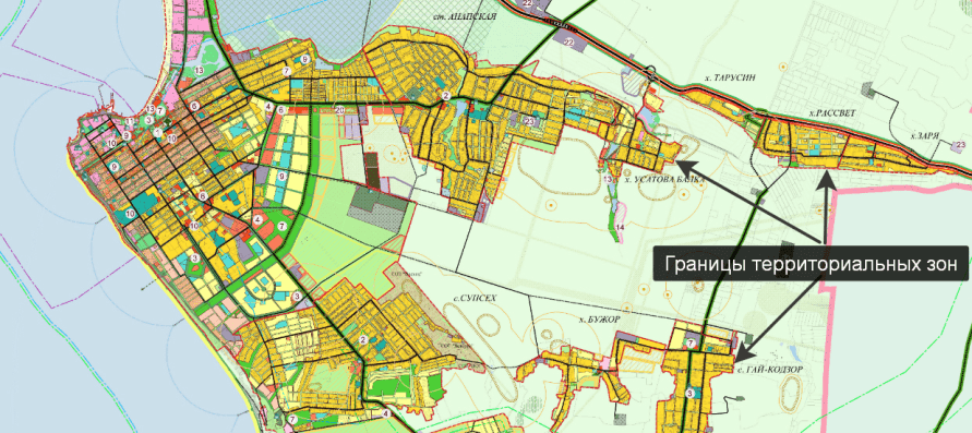
In the screenshot, a fragment of the map municipality Anapa.
The territorial zones indicated on the map differ in color, and each has its own borders.
The housing development area is highlighted in yellow.
When choosing the location of the site, it is impossible to allow the boundaries of the site to cross the boundaries of the territorial zone.
Follow this requirement and avoid rejection on the third ground.
4. The scheme does not comply with the approved territory planning project, land management documentation and the regulation on a specially protected natural area.
Approved site planning project, as well as all regulations, is a public document. The draft plan is posted on the website of the administration.
The approved project consists of drawings, maps and descriptions.
Why do you need a site plan?
The planning project determines the red lines and the placement of capital construction projects.
In addition, the planning project establishes the boundaries of the territories of cultural heritage sites.
The planning project takes into account the scheme of the boundaries of zones with special conditions of use and other parameters.
If you are preparing a scheme for obtaining a site for individual housing construction and the selected site is close to the business and public centers of the settlement, borders on the roadway, then it is advisable to study the layout project so as not to cross the red lines at least.
In small settlements, a planning project may not be available at all.
The absence of a planning project excludes its violation when drawing up a diagram.
What is land use documentation?
Let's start with a definition: what is land management?
Land management is Events on studying the condition of lands, planning and organizing the rational use of lands and their protection, describing the location and (or) establishing the boundaries of land management objects on the ground, organizing the rational use of land for agricultural production, etc.
For a complete definition of land management, see Article 1 of the Law "On Land Management" dated June 18, 2001 N 78-FZ.
It follows from the definition that land management is an event, that is, the actions of the authorities.
Land management documentation - these are documents obtained as a result of land management.
In other words, land management documentation is any document of authority obtained as a result of the above activities.
We give examples of land management documentation.
Types of land management documentation.
- Scheme of land management of the territories of the constituent entities of the Russian Federation.
- General scheme of land management of the territory of the Russian Federation.
- Scheme of land management of municipalities.
- Land use and protection schemes.
- Maps (plans) of land management objects.
- Projects of on-farm land management.
- Materials of soil, geobotanical and other surveys and surveys, land quality assessment, land inventory.
- Projects for the improvement of agricultural land, the development of new lands, the reclamation of disturbed lands, the protection of lands from erosion, mudflows, flooding, waterlogging, secondary salinization, desiccation, compaction, pollution by industrial and consumer waste, radioactive and chemicals, infection and other negative impacts.
- Thematic maps and atlases of the state and use of land.
The above list is open.
Local and regional authorities can introduce their own types of land management documentation.
How to avoid violating the requirements of land management documentation?
To begin with, find out what, in principle, land management documentation is in force in the settlement.
I use examples to obtain land for individual housing construction.
How to find land management documentation?
On the administration website, find the "Search Site" field and enter the types of documents one by one.
For example: land management scheme; map of land management facilities; soil survey materials, etc.
If there is no search on the site, then enter the name of the documents in any search engine, adding the name of the settlement.
Then, review the found documents to find out how they relate to the territory in which you want to map the site.
Note.
Materials of soil, geobotanical and other surveys, as well as land quality assessments will help you make the right choice of site.
Therefore, spending half a day identifying land management documentation on the administration's website is not a big price to pay for choosing a site with quality soils.
Regulations on a specially protected natural area.
Specially protected natural areas are areas of land, water surface and air space above them, where natural complexes and objects are located that have a special environmental, scientific, cultural, aesthetic, recreational and health value.
Specially protected natural territories are withdrawn by decisions of state authorities in whole or in part from economic use.
For these territories, a regime of special protection is established.
On the sites of local administrations, where officials are friends with brains, there are special sections on land issues.
In these sections, as a rule, the Rules for Land Use and Development, Regulations on Specially Protected natural areas, planning projects of the territory, land management and other documentation.
A cursory reading of these documents allows you to determine how the documents relate to the territory where you are going to get a plot.
If you have not established any limiting facts, then you can safely make a scheme, observing, first of all, the Land Use and Development Rules.
5. The project of land surveying 100% excludes the approval of the scheme of the land plot.
For individual territories local authorities may approve land survey projects.
Only the administration forms plots in territories with an approved land surveying project.
From this follows the conclusion.
If there is a survey project in the cadastral quarter, then you are looking for a plot in another quarter.
Because the approval of the land plot scheme will come to a standstill.


The administration cuts plots of the same size in cadastral blocks with approved land surveying projects. As a rule, plots are cut for presentation at auctions.
Plots formed by blocks are clearly visible on the public cadastral map. In such blocks, almost all areas are of the same shape and size.
If you see such blocks on the PKK, then it can be assumed that a land surveying project is operating on the territory.
How to check if there is an approved survey project?
One way is as follows.
Required in any search engine print the number of the cadastral quarter.
Dial the number of the quarter in which you want to draw a map.
In the search results, you need to check for a mention of an approved survey project.
It is desirable to conduct the same search on the administration website.
If there is no mention of the approval of the project for surveying the territory, then with high probability it follows that there is no land surveying project.
However, you need to understand that the Internet does not give a 100 percent guarantee.
The optimistic situation is as follows.
There is no mention of the survey project on the Internet.
On the site of the administration and on the PKK, the cadastral quarter does not contain blocks of beautifully cut sections.
If the picture is like this, then you can make a diagram of the site.
We considered 5 grounds for refusing to approve the layout of a land plot.
If you have any questions: ask in the comments.
Use ready-made videos to map out the site. Because preliminary approval gives a chance to get a land plot without bidding.
I wish you a decent life and successful land acquisition.
Tags: ,